

The Colorful Mountains of Cusco await you with breathtaking views, trekking routes, and the magic of the Andean landscape.
Table Of Content
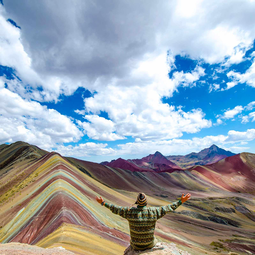
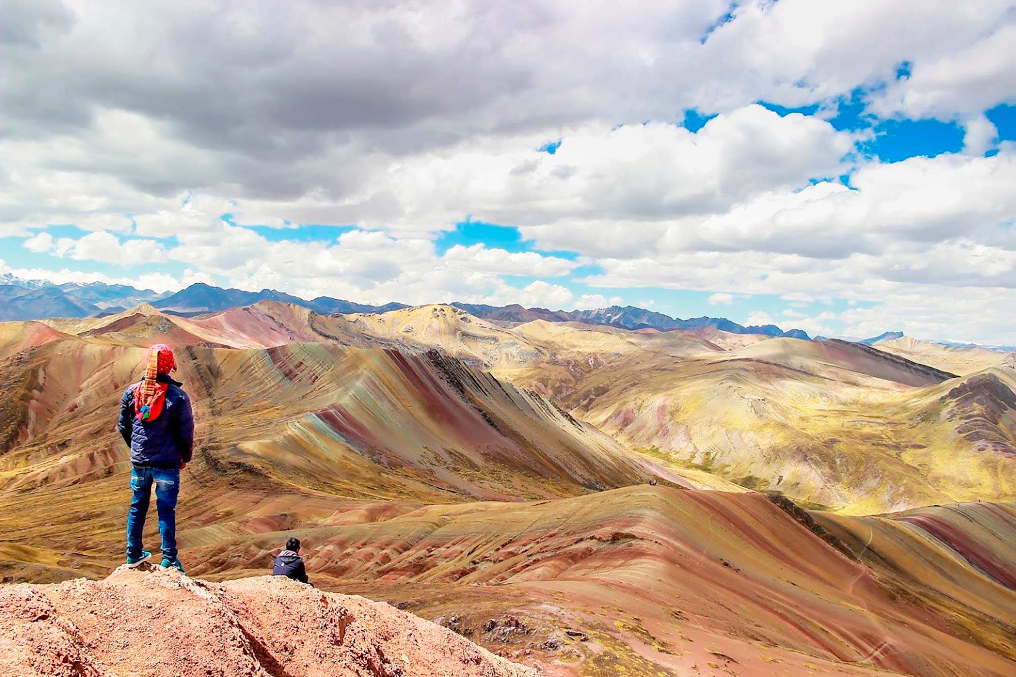
The Seven Colors Mountain, also known as Vinicunca or Rainbow Mountain, is a remarkable geological formation showcasing a variety of colors due to the mineralization and oxidation of sedimentary rocks over millions of years. These colors are derived from minerals such as iron oxide (pink/red), copper oxide (green), and sulfur (yellow). Vinicunca is historically significant to Andean culture. Local communities revered it as a sacred “Apu,” or mountain deity, believed to protect them. While there are no specific Inca sites on the mountain, its proximity to the Inca Trail and Machu Picchu connects it to the broader Inca heritage. In recent years, Vinicunca has experienced a surge in tourism, transforming from a little-known site to a popular travel destination.
The 7 Colors Mountain is not only a visual spectacle, but also an open book of the earth’s history. Each layer of minerals represents a different geological era, and its current appearance is the result of millions of years of tectonic movements and erosion. For geology lovers, Vinicunca is a fascinating destination that combines beauty and science.
Geological formation: Vinicunca was formed during the Cretaceous period, between 75 and 63 million years ago (Campanian-Lower Paleocene). During this period, the region experienced intense tectonic and volcanic activity, resulting in the formation of mineral-rich sedimentary layers. Erosion and exposure over millions of years have revealed the spectacular geological rainbow that we can observe today.
Mountain climate of the 7 colors
Vinicunca, also known as the Seven Colors Mountain, is located in the Peruvian Andes and experiences a cold and variable climate due to its high altitude. Significant temperature fluctuations between day and night are a key feature of the climate. While it may feel warm during the day under strong sunlight, temperatures can plummet after sunset or during cloudy conditions, sometimes falling below freezing at night.
The region has two primary seasons: the dry season from April to October, which is ideal for visiting because of reduced rainfall and clearer skies, though nights are colder; and the rainy season from November to March, which is characterized by frequent rain that can make trails slippery and obscure views, though daytime temperatures are usually warmer. It is crucial to prepare for the weather, and it is recommended to dress in layers and carry warm clothing, a hat, gloves, and a waterproof jacket or poncho to handle the potential for cold and rapidly changing weather.
What are the routes of the colored mountain?
Rainbow Mountain, also known as Vinicunca, is a remarkable destination in Peru. It is renowned for its vibrant colors and stunning natural landscape, which attract numerous travelers from around the world. There are three primary routes that provide access to this scenic wonder, each of which caters to different preferences and hiking styles.
1. Checacupe – Pitumarca Route: This route is ideal for adventure enthusiasts. It is an 8-kilometer round-trip from Kayrawiri to Vinicunca, with an approximate hiking time of two and a half hours one way. Advantages include a less crowded trail, allowing for a tranquil experience, and stunning Andean landscapes along the way. However, the bus ride from Cusco is longer compared to other routes.
2. Cusipata Route: This route is the most popular among tourists. It covers 7 km round trip from Phulawasipata to Vinicunca and takes about 1 hour and 30 minutes one way. Its advantages include easy accessibility, availability of services, and the chance to visit the picturesque Red Valley, all due to its popularity. The downside is potential overcrowding, especially during peak seasons.
3. Ausangate Route: This 15-kilometer route is suitable for adventure seekers and spans four days and three nights, focusing on trekking. It offers a unique journey through pristine nature with breathtaking views of Rainbow Mountain and the snow-capped peak of Ausangate. As a lesser-known path, it promises an authentic experience away from tourists, but it requires high physical fitness and acclimatization in Cusco to counteract altitude sickness.
Understanding these options helps prospective visitors choose the route that best aligns with their interests and hiking capabilities.
Important dates:
Location: Pitumarca
Max. altitude: 5100 m/16 732 ft.
Hike time: 2-3 h
Activity level: challenging
Distance: 7 km
Palcoyo Colored Mountain
History of Palcoyo Colored Mountain
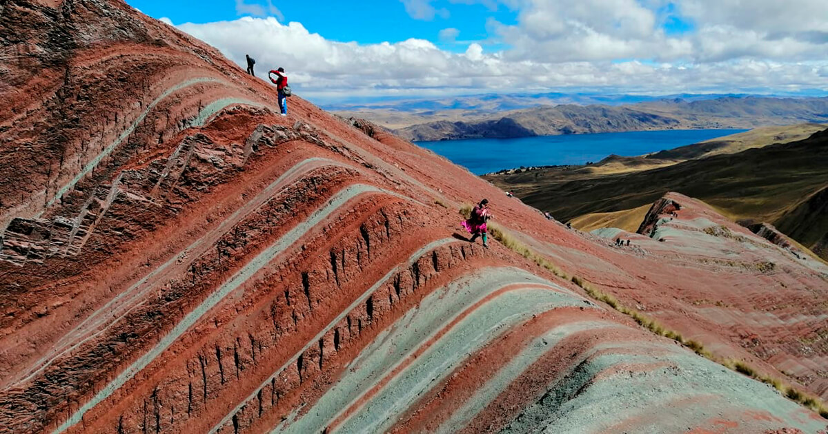
The Cordillera Vilcanota mountain range, established over 200 million years ago, is noted for its vivid colors, particularly in the Palcoyo and Vinicunca mountains. These colors result from specific mineral and sediment arrangements, including red clay, limestone, quartz, lavender clay, and green soil. The coloration process occurred due to temperature fluctuations that caused mineral separation, preserved under snow cover. However, recent climate change is hastening glacier melt, which exposes these formations while jeopardizing water sources in the high Andes. Geologists highlight the significance of the mountains’ shapes and colors, reflecting a unique geological history shaped by environmental changes.
How to get to Palcoyo Mountain?
The easiest way to get to Palcoyo is to follow the road that connects Cusco with the route to Arequipa or Puno. On this road is the district of Checacupe, from where you continue the journey to Pitumarca (others recommend making the trip to Combapata, from where you can also find transportation). To get to Palcoyo, it is essential to get to Pitumarca; otherwise, it will probably take you longer than usual to get to this colorful mountain.
Currently, it is possible to make the trip with the assistance of a travel agency or on your own. If you decide to do the trip with a tour agency in Cusco, you will only have to pay the total price of the tour. They will provide you with breakfast, lunch and the essential: transportation. The possibility of doing the trip on your own is totally viable, the economic expense is less and you can do it with the time that best suits you. However, it is necessary to be attentive to all the necessities to arrive first to Pitumarca and then to Palcoyo. It will be necessary to get transportation.
On the other hand, it should be noted that the road is easy. The transport will leave us two kilometers from Palcoyo. This route has to be done on foot. The walk is not complicated, although the first kilometer is uphill, then it is almost flat. It is not a complicated walk, which is why it is recommended to do it with the whole family. Of course, it will be necessary to acclimatize to have a better experience. As we will see below.
Important dates:
Location: Checacupe
Maximum Altitude: 4900 m/16 076 ft.
Hike time: 1 h and 30 min
Activity level: moderate
Distance: 3 km
Pallay Punchu Mountain
History of Pallay Punchu Mountain
The majestic mountain of Pallay Punchu, whose Quechua name means “decorated poncho,” is much more than a beautiful geographical feature. Its history dates back to 250 million years ago, during the formation of the earth’s crust. At that time, the accumulation of minerals, earth and sand in layers was interrupted by the collision of the South American and Nazca tectonic plates, creating the imposing mountain ranges, hills and slopes that characterize the region.
But how did this impressive place become known to the world? It all began in April 2020, during the coronavirus (Covid-19) quarantine, when Tony Ccalta climbed the hill of Pallay Punchu in search of Sasawi medicinal plants for his parents. He was amazed by the beauty of the surroundings and decided to immortalize the moment by sharing photos and videos on his social networks. The content quickly went viral.
In addition to its scenic beauty, Pallay Punchu has become a refuge for the local community. Sasawi, a native medicinal plant, has been used in the area for generations to treat respiratory ailments, making it a valuable resource for the well-being of those who live nearby. Thus, this mountain is not only a sight to behold, but also holds a valuable cultural and medicinal heritage for the people around it.
How to get to Pallay Punchu Mountain?
Below we show you the two ways to get there so you can choose the one that best suits your travel style:
On your own:
Begin your trip by leaving Cusco by public transportation to Sicuani. Once there, look for transportation that will take you to Layo, the village near Pallay Punchu. Once you arrive, find out about the route and hike to the viewpoint of the mountain, which will take between 45 minutes and an hour.
With a tour to the mountain of Pallay Punchu:
Do your research and choose a reputable travel agency in Cusco. At Qeswachaka Peru Tours we offer a day tour to Pallay Punchu where we take care of the details such as duration, itinerary and services included. We will pick you up in Cusco and a guide will accompany you during the trek. Enjoy a carefree and organized experience.
Important dates:
Location: Layo
Maximum Altitude: 4700 m/15 419 ft.
Hike Time: 2 hrs
Activity Level: Moderate
Distance: 3 km
Be prepared for altitude sickness:
Visitors to Cusco often underestimate the effects of the city’s high altitude, which can lead to unexpected altitude sickness, particularly while traveling. The city sits at an elevation of 11,155 feet, and many excursions begin at this minimum elevation, reaching up to 16,404 feet. To mitigate the risk of altitude sickness and enhance your trekking experience, it’s essential to acclimatize properly. It is advisable to arrive in Cusco at least two days before any trekking activities. This allows newcomers to adapt to the climate and altitude, preparing them for their treks. Further reading on proper acclimatization techniques in Cusco is recommended for more detailed guidance on preventing altitude sickness. How to avoid altitude sickness
If you are not accustomed to the lack of oxygen at high altitudes, you may experience symptoms such as headaches, fatigue, or nausea. To better acclimate, follow these recommendations:
1. Stay hydrated. Due to the risk of rapid dehydration at high altitudes, it is crucial to drink plenty of water.
2. Don’t force yourself. Upon arriving in places like Cusco, take the opportunity to explore, but do so at a relaxed pace that respects your body’s needs.
3. Get adequate rest. Your body undergoes significant stress adapting to higher altitudes, so proper rest is essential for recovery.
4. Eat properly. Steer clear of heavy meals that could lead to prolonged digestion and discomfort.
5. Drink coca tea. This traditional Andean remedy, made from coca leaves, helps mitigate symptoms of altitude sickness. It can also be blended with other local plants, such as muña, for enhanced benefits.


No Comment! Be the first one.