


Ica, Peru: A place of history, culture, and adventure between the desert and the sea
The region of Ica is located on the southern coast of Peru, about 300 kilometers south of Lima. The sunny year-round climate, rich pre-Columbian history, and unique desert landscape define the city of Ica, which has Ica as its capital.
Table Of Content
- Huacachina is a natural oasis located in the heart of the Peruvian coastal desert.
- Location and Geographical Features
- Origin and Formation
- Brief History and Legend
- Ecosystem and Conservation
- Climate
- Main Tourist Activities in Huacachina
- Dune buggy rides
- Sandboarding involves sliding down dunes
- Walking and Hiking in the Dunes
- Take a boat ride on the lagoon.
- General Recommendations for Activities in Huacachina
- Tourist services are available.
- Curious Facts
- Current Problems
- Recommendations for Visitors
- Paracas, Peru: A Guide to Discovering the Coastal Paradise
- What is the best time to visit?
- History
- Take a tour of the Ballestas Islands
- Why should you visit the Ballestas Islands?
- The Mystery of the Candelabro
- The Outstanding Fauna of the Ballestas Islands
- Fur seals
- Humboldt Penguin
- Guano Birds
- Other species
- Here are some recommendations for your excursion to the Ballestas Islands
- The Nazca Lines are a millenary mystery in the Peruvian desert
- Which figures are the most important?
- The hummingbird of the Nazca Lines
- Dimensions
- Possible meaning
- Creation Technique
- Cultural Importance
- How can you see it?
- The monkey is one of the geoglyphs of the Nazca Lines
- Location
- Characteristics
- Possible meaning
- How was it made?
- How can you see it?
- Cultural Importance
- The Giant Bird is one of the geoglyphs of the Nazca Lines
- Location
- Features
- Possible meanings
- Creation method
- How can you see it?
- Tourist and cultural relevance
- The Geoglyph of the Spider from the Nazca Lines
- Location
- Characteristics
- Species Represented
- Possible meaning
- How did they make it?
- Cultural relevance
- The Owl Man, also known as the Astronaut, is one of the Nazca Lines’ geoglyphs
- Location
- Characteristics
- Is it a man or an owl?
- Why do they call it “The Astronaut”?
- Possible meanings
- How did they make it?
- How to see it?
- Cultural relevance
The region is located between the Pacific Ocean and the Andes Mountains. This location hosts a variety of ecosystems, including imposing dunes, natural oases, and fertile valleys where farmers grow grapes, cotton, and fruit.The region’s warm, arid climate is ideal for wine production.
Ica is famous for being the birthplace of pisco, Peru’s national drink, as well as for being home to one of the few natural oases in South America, the Huacachina Lagoon. The region is also home to impressive archaeological remains of ancient cultures, such as the Nazca and Paracas peoples. The mummies, ceramics, textiles, and the mysterious Nazca Lines showcase the legacies of the culture, and UNESCO has declared them a World Heritage Site.
The region offers other natural attractions of great value, such as the Paracas National Reserve and the Ballestas Islands, which are famous for their marine biodiversity.
Huacachina is a natural oasis located in the heart of the Peruvian coastal desert.
The Huacachina Lagoon, located in Peru’s Ica region, showcases one of South America’s most unique landscapes. Geological processes and human intervention shaped this natural oasis, nestled in the middle of the Pacific coastal desert, while tall sand dunes encircle it.The area has transformed from a local attraction into an international tourist destination, generating significant economic, social, and ecological impacts.
Location and Geographical Features:
Geographic coordinates: 14°05′00″ S, 75°45′00″ W.
Altitude: approximately 400 meters (1,312 feet) above sea level.
The climate is arid subtropical, with low rainfall (less than 20 mm per year) and average temperatures ranging from 25 to 30 °C (77 to 86 °F).
The lagoon is located in the Sechura Desert, one of the driest deserts in the world. The surrounding dunes, which are over 100 meters high, are the result of centuries of wind-blown sand accumulation (aeolian formations). The unusual presence of a body of water in this extremely dry environment makes Huacachina an exceptional endorheic lake system.
Origin and Formation:
The upwelling of groundwater from aquifers fed by the Ica River’s filtration naturally creates the lagoon. These phreatic waters emerged in a topographic depression, creating a small, permanent body of water in the middle of the desert. However, due to the overexploitation of the aquifer and scarce rainfall, the lagoon has greatly reduced in volume since the mid-20th century. This has made it necessary to pump groundwater artificially to maintain its current level.
Brief History and Legend
The history of Huacachina as a tourist destination dates back to the early twentieth century, when it was a health and recreation destination for Lima’s elite due to the alleged healing properties of its lagoon’s waters.
The most famous legend says that a young Inca princess cried so much over the death of her beloved that her tears formed the lagoon. When a stranger discovered her bathing, she submerged in the water and became a mermaid. Since then, people believe that her spirit still lives in the lagoon’s depths.
Ecosystem and Conservation
La Huacachina is a fragile ecosystem. Originally, the lagoon was naturally fed by groundwater from the Ica River aquifer. However, due to the overuse of agricultural wells and increased urban activity, the water level has dropped drastically in recent decades.
Currently, workers pump groundwater to artificially maintain the oasis and preserve the reflective surface of the water. This system requires maintenance and technical control to prevent excessive evaporation and maintain ecological balance.
In 2014, authorities established the Laguna de Huacachina Regional Conservation Area to protect 2,400 hectares of desert and regulate tourism and extractive activities.
Climate:
Climate Type: Dry Subtropical Desert
The average annual temperature is between 25 and 32 °C.
Precipitation: Less than 20 mm per year (extremely dry).
Solar radiation is high all year round.
Best time to visit: April to November (clear skies and fewer tourists).
Main Tourist Activities in Huacachina:
Dune buggy rides:
One of the main attractions in Huacachina is riding in a dune buggy. These all-terrain vehicles travel through the huge sand dunes surrounding the oasis. You can experience the thrill of driving or riding while crossing slopes and jumping sand ridges. You will also enjoy panoramic views of the desert and lagoon.
Average duration: One to two hours.
Adrenaline level: high. It’s ideal for adventurers and thrill-seekers.
Safety precautions include mandatory helmet use and supervision by expert guides.
Tip: Book in advance and verify that the company complies with safety standards.

Sandboarding involves sliding down dunes
This activity has grown in popularity among tourists and young athletes. Similar to snowboarding, participants slide down sandy slopes on a special board.
There are options for both beginners and experts.
Equipment: Tourist agencies provide boards and protective gear for your hands and feet.
Recommendation: Take a short introductory class to learn the technique and avoid injury.
Sandboarding is a fun, active way to experience the desert landscape.

Walking and Hiking in the Dunes:
For those who prefer a quieter, more intimate experience with nature, walking through the dunes is an excellent option. As you hike up, you can enjoy the majesty of the desert, breathe in the fresh air, and take in the unique panoramic views of the lagoon from above.
Difficulty level: Moderate to high due to the heat and soft sand.
The duration ranges from 30 minutes to several hours, depending on the route.
The best times are sunrise and sunset to avoid high temperatures and enjoy optimal lighting for photography.
Tip: Bring water, a hat, and sunscreen.

Take a boat ride on the lagoon.
Although small, they offer a unique, relaxing experience. Renting a pedal or paddleboat allows you to enjoy the tranquility of the water while surrounded by palm trees and natural reflections.
It is ideal for: – Families
– Couples
– People looking for a moment of calm after adventuring.
Duration: 15 to 30 minutes per trip.
Tip: Visit early to avoid the hottest hours and enjoy the scenery without crowds.

General Recommendations for Activities in Huacachina:
Wear light, skin-covering clothing to avoid sunburn.
Drink plenty of water to prevent dehydration.
Respect the ecosystem by not littering or damaging the vegetation.
Use certified tourist services that prioritize safety and environmental protection.
Tourist services are available.
Accommodations range from budget backpacker hostels to boutique hotels with a swimming pool and direct views of the oasis.
There are also guesthouses, lodges, and organized campsites in the surrounding areas. There are also guesthouses, lodges, and organized campsites in the surrounding areas.
Restaurants and bars offer Peruvian, international, vegetarian, and gourmet cuisine.
They offer Peruvian, international, vegetarian, and gourmet cuisine. There are also bars with terraces facing the lagoon that offer live music and cocktails with pisco.
There are also agencies and tour operators.
Many agencies offer excursions in and out of the oasis, including:
– Buggy and sandboarding excursions.
– Pisco winery tours.
– Excursions to Paracas, the Ballestas Islands, and the Nazca Lines.
Curious Facts:
They have artificially maintained the lagoon for over ten years.
Huacachina is one of the few places in the world where you can practice sandboarding in a natural, tourist-friendly environment.
Travelers have chosen Huacachina as one of the most Instagram-worthy destinations in South America because of its unique landscape.
Current Problems:
Tourist pressure: Overcrowding has had a visible environmental impact, including dune erosion, water pollution, and the loss of native flora.
Lack of regulation: Informal services operate without safety measures or sustainability.
Evaporation of water: Extreme heat and a lack of vegetation threaten the lagoon’s water balance.
Garbage: The amount of solid waste increases considerably during holidays.
Recommendations for Visitors:
Wear sunscreen, sunglasses, and light, breathable clothing to protect yourself from the hot sand.
Bring drinking water, especially if you plan to participate in physical activities.
Only hire tours from authorized and safe operators.
Do not leave garbage on the dunes or in the lagoon.
Support local tourism by purchasing regional products and food.
Huacachina is much more than just a tourist oasis. It is a natural enclave in the Peruvian coastal desert representing the fusion of myth, landscape, adventure, and culture. The transformation of a natural environment into an economic engine and a recreational space exemplifies how it can serve as an identifying symbol of a region.
However, its sustainability depends on striking a balance between responsible tourism, environmental conservation, and community participation. Visiting Huacachina is a unique experience and an opportunity to reflect on the fragility of ecosystems and the importance of responsible tourism.
Paracas, Peru: A Guide to Discovering the Coastal Paradise
Paracas offers access to the Paracas National Reserve, a pristine desert landscape where enormous colonies of sea lions and seabirds gather to bask in the nutrient-rich waters of the Peruvian coast. Guests can enjoy the fascinating desert dunes or observe the wildlife of the Ballestas Islands. After a day spent enjoying nature, unwind by the resort pool with a view of beautiful Paracas Bay.
If you have extra time, consider taking a flight over the Nazca Lines. Planes depart from the nearby Pisco Airport and return to Paracas in time to watch the sunset. Other activities for thrill-seekers include kayaking, biking, and quad biking in the Paracas Reserve, as well as buggy and sandboarding tours.
What is the best time to visit?
The best months are during the southern hemisphere’s summer, from December to March, when the days are hot and the sky is clear. Paracas’s coast receives many visitors during this time, as Peruvians enjoy their summer vacations then.
The best time to observe the fauna depends on the species you want to see. You can see different species of birds or aquatic animals depending on the season. For instance, you can best see penguins from April to November. You can spot sea lions year-round, so you won’t miss them.
History
The Paracas culture developed on the Paracas Peninsula around 900 BCE. Its inhabitants were fishermen and farmers who cultivated beans, corn, and red peppers. Excavations at the Paracas necropolis suggest that highly skilled artisans created the Paracas culture. They made obsidian knives, fine pottery, shell and bone necklaces, gold ornaments, and finely woven textiles. Archaeologists have found these artifacts in the underground tombs. The dry climate and lack of light in these burial chambers ensured the preservation of these artifacts.
On September 8, 1820, the “Liberating Expedition,” led by Argentine General José de San Martín, landed in the Bay of Paracas with over four thousand soldiers. During his time there, he supposedly designed the Peruvian flag, inspired by the pink flamingos native to the Paracas Peninsula. The liberating force then marched toward Lima with the goal of freeing the South American colonies from Spanish imperial rule.
In 1925, a team of archaeologists led by Julio C. Tello began excavating the Paracas Caverns, a communal burial site dating from 300 to 200 BCE, as well as the Wari Kayan site. There, the team found bundles of mummies wrapped in cloth, feathered costumes, jewelry, and food offerings. Archaeologists found textiles from the Nazca culture at the Paracas site. Together, they refer to the two sites as the Paracas Necropolis. In 1975, the Peruvian government established the Paracas National Reserve.

Take a tour of the Ballestas Islands
Paracas Bay is the departure point for boat tours to the Ballestas Islands. Excursions typically depart in the morning at 8 or 10 a.m. During the trip, you will see the geoglyph El Candelabro, which artists engraved on the Paracas Peninsula.You will navigate through caves and arches, as well as rocky islands inhabited by large colonies of seabirds and sea lions. If you’re lucky, you may also spot dolphins, orcas, turtles, and other exotic creatures. Please note that the boats do not have decks. Be prepared for cold, windy conditions and the occasional bird dropping. Dress appropriately; a windbreaker, poncho, or hat is recommended.
Why should you visit the Ballestas Islands?
Known as the “Peruvian Galapagos,” the islands are home to a variety of species that can only be observed in their natural habitat. During the boat tour, you will see colonies of sea lions, Humboldt penguins, and guano birds, including pelicans and cormorants. This abundance of wildlife makes the islands an ideal place for birdwatching and photography.
The Mystery of the Candelabro
One of the most iconic attractions is the geoglyph known as the Candelabro, a massive figure carved into the desert sand visible only from the sea. Standing over 180 meters high, the origin and purpose of the Candelabro remain a mystery, adding a fascinating touch to the visit.

The Outstanding Fauna of the Ballestas Islands
The Ballestas Islands, located off the coast of Paracas, Peru, are a natural refuge for a variety of marine species and birds. This makes them an ideal ecotourism destination for observing wildlife in its natural habitat.
Fur seals
These marine mammals are undoubtedly the most visible and charismatic inhabitants of the islands. They can be seen resting on the rocks, swimming near boats, and interacting in groups, displaying fascinating social behaviors.

Humboldt Penguin
This species is considered vulnerable by the International Union for Conservation of Nature (IUCN) and is endemic to the South Pacific coast. They are found in small colonies in the Ballestas Islands, one of the few accessible areas in Peru where they can be observed.

Guano Birds
The islands are a sanctuary for several species of guano birds, including:
Pelicans
Cormorants.
Curlews
Boobies.
These birds are essential to the ecosystem because their droppings, known as guano, have historically been important to agriculture and the local economy.

Other species:
During the excursion, dolphins can occasionally be seen swimming around the boats.
Chungungos, small marine mammals, also inhabit the area.
You can also observe the great variety of fish and other marine life in this protected ecosystem.


Here are some recommendations for your excursion to the Ballestas Islands
Before the tour:
Book in advance, especially if you are coming on weekends, holidays, or during the high season (July–August and Easter).
Arrive early. You should be at the pier at least 30 minutes before the scheduled departure time.
Check the weather, as the tour may be canceled in case of heavy fog or rough seas.
What to Bring:
Sunscreen: The sun’s reflection on the sea can be intense, even in winter.
A cap, hat, or sunglasses to protect you from the sun and wind.
A light coat or windbreaker because the air at sea can be cold, even in the summer.
– Camera or cell phone with a charged battery: The wildlife and landscapes are very photogenic.
Water bottle: Stay hydrated during the trip.
Bring seasickness pills if you are prone to seasickness, as the sea can be rough and the boat sways a lot.
During the tour:
Do not feed or touch the animals.
Do not throw garbage into the sea.
Always listen to the guide’s instructions.
Remain seated while the boat is in motion.
Important Data:
Do not disembark on the islands, as they are protected areas.
Bring cash to pay the mandatory SERNANP and boarding fees.
Children must be accompanied by an adult and wear a life jacket at all times.
The Nazca Lines are a millenary mystery in the Peruvian desert
The Nazca Lines are a large group of geoglyphs in the form of lines drawn in the desert. Most of the lines depict animals or plants, though there are also geometric shapes, straight lines, and undefined and anthropomorphic shapes.
They are located in the Nazca Desert, 415 kilometers (258 miles) south of Lima.
There is much more to discover in this region. Consult this guide to tourist sites in Nazca to plan your visit.
The Nazca culture apparently drew these figures between 100 and 600 CE.
Archaeologist Toribio Mejia Xesspe discovered the lines in 1927, but interest in studying and investigating them did not arise until 1940 when the National Aerographic Service released aerial photographs of them.
For years, people have tried to decipher the purpose of the Nazca Lines, but this remains a mystery to this day.
Some of these lines measure up to 300 meters in length. They are not the only geoglyphs in the world, but they are the largest and most renowned. In fact, UNESCO has declared them a World Heritage Site. The lines occupy an area between 450 and 800 square kilometers.
They have been well preserved over time thanks to the area’s climate. Temperatures average 25 °C, and rainfall is scarce.
The figures are best appreciated from high altitudes. While some can be seen from the nearest hills, the best option is to fly over them.
Beyond the various theories about their meaning and creation, it has been concluded that these figures cannot be correctly observed from the ground. Therefore, their design and realization must have been directed from a high place.
Because of the accuracy of some of the figures, even the larger ones, it is presumed that those who created these drawings used grids made of ropes and wooden stakes to transfer the designs to scale while maintaining harmonic proportions.
Which figures are the most important?
We will mention some of the most representative and characteristic ones, whose photographs have gone around the world.
Next, we will mention the names of the Nazca Lines that are among the most notable:
The hummingbird of the Nazca Lines
Location:
The Hummingbird Geoglyph is located in the Nazca Pampas, among the figures traced in the desert of Peru’s Ica Region.
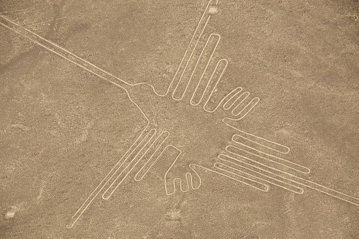
Dimensions:
Approximate length: 93 meters.
The lines are fine, well-defined, and perfectly symmetrical.
The boat can only be fully appreciated from the air.
Possible meaning:
Although not definitive, the hummingbird could have had several meanings.
– Fertility symbolism: linked to water, flowers, and life.
– Astronomical calendar: Aligned with the solstice or agricultural seasons.
– Spiritual element: a messenger between gods and humans due to its fast, precise flight.
Creation Technique:
This is achieved by removing the dark stones from the ground, which exposes the lighter desert underlayer.
The resulting contrast forms the visible outline of the hummingbird.
Thanks to the dry climate without rain or strong winds, the figure has remained intact for centuries.
Cultural Importance:
The hummingbird is one of the most iconic and frequently photographed figures of the Nazca Lines. Its geometric perfection and beauty have made it a symbol of Nazca culture and Peruvian pre-Columbian art.
How can you see it?
It is clearly visible during an overflight by a light aircraft, along with other figures, such as the monkey, the condor, and the spider.
It is not visible from a ground-based viewpoint.
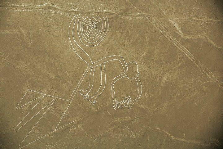
The monkey is one of the geoglyphs of the Nazca Lines
Location:
El Mono is located in the Pampa de Jumana, part of the Nazca Geoglyphs Complex in Peru’s Ica Desert.
Characteristics:
Approximate size: 135 mm long.
Design: It depicts a monkey with a spiral body, a long, curled tail, and nine visible fingers and toes.
Its geometric and abstract style is characteristic of Nazca art.
Possible meaning:
Although its exact meaning is unknown, several meanings have been attributed to it.
Astronomical Relationship: Some researchers believe it could be related to constellations or the movement of the stars.
Agricultural or ritual symbolism: It may have been used in ceremonies related to water and fertility.
Cultural connection: In Nazca culture iconography, monkeys also appear in ceramics and textiles.
How was it made?
Like the other lines, it was created by removing the top layer of dark desert stones and exposing the lighter earth beneath.
The region’s dry, windless climate has preserved the geoglyph for over 1,500 years.
How can you see it?
The monkey can only be seen from the air during a small plane overflight.
It cannot be seen from the ground, yet it is one of the most requested sights for tourists.
Cultural Importance:
The Monkey geoglyph is famous for its size, design, and complexity. An emblem of the Nazca culture, it is widely reproduced on postcards, books, and tourist materials.
The Giant Bird is one of the geoglyphs of the Nazca Lines
Location:
The giant bird is located in the Nazca Pampas in southern Peru. It is one of more than 300 figures drawn in the desert by the ancient Nazca civilization.

Features:
Approximate length: more than 280 meters!
It is one of the largest geoglyphs discovered to date.
The design depicts a bird with outstretched wings and an elongated beak, rendered with simple yet imposing strokes.
It is believed to represent either a seabird or a stylized condor.
Possible meanings:
Though its interpretation is still debated, some theories suggest the following:
Like many other birds in Andean cultures, it represents spiritual power or a connection to the sky.
It may have been part of a system of ritual or astronomical signals.
It has also been associated with the worship of water and the sun, which are fundamental elements for agriculture in the desert.
Creation method:
It involves removing dark stones from the desert to reveal the light-colored sand beneath.
The full extent of its size can only be appreciated from the air. Thanks to the dry and stable climate, it has remained intact for centuries.
How can you see it?
The Giant Bird cannot be seen from the ground. It can only be observed during a flight in a small airplane from Nazca, Ica, or Paracas.
During the flight, you will see other figures, such as the hummingbird, monkey, and condor.
Tourist and cultural relevance:
It is one of the most impressive figures due to its size and shape.
Its size demonstrates the technical and symbolic knowledge of Nazca culture.
The mysticism surrounding the Nazca Lines captivates viewers, and they see one of the most impressive images from the air.
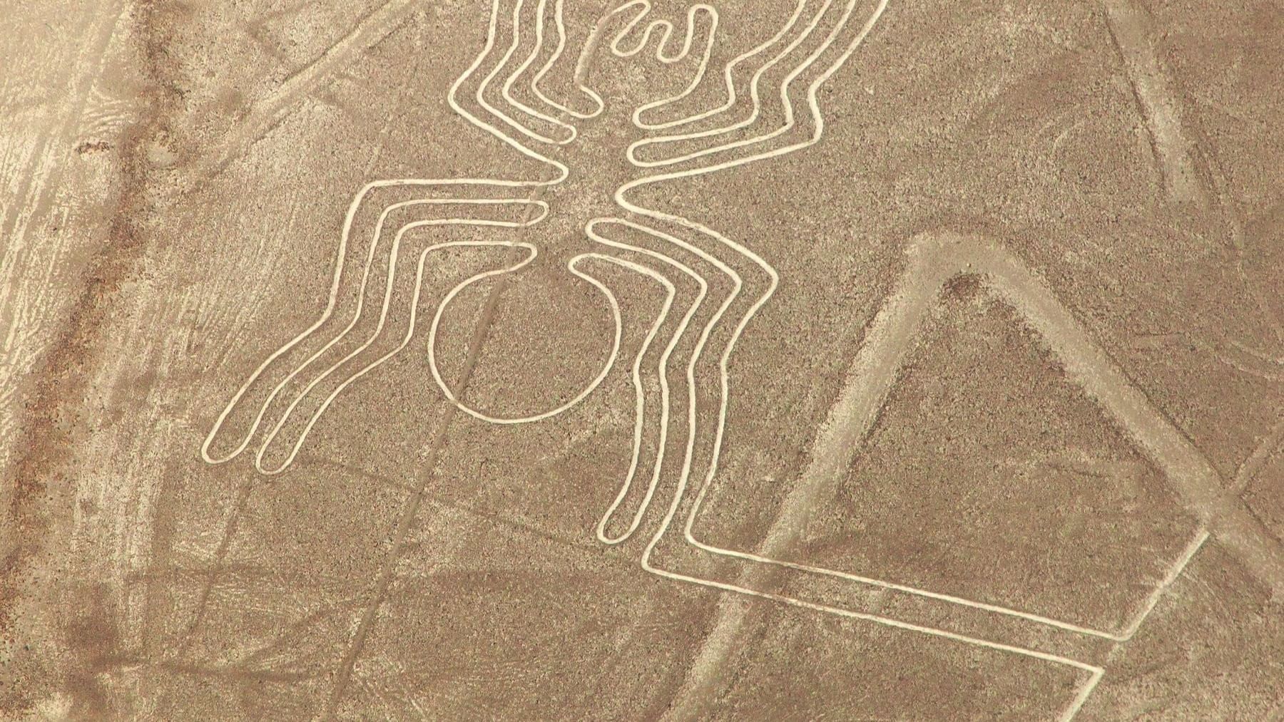
The Geoglyph of the Spider from the Nazca Lines
Location:
The Spider figure is located in the Nazca Pampas, a coastal desert in southern Peru. The Nazca culture created a group of geoglyphs, of which this is a part.
Characteristics:
Size: approximately 46 meters long.
It precisely depicts a spider with a slender body and elongated legs.
Its straight, clean lines demonstrate great geometric knowledge and artistic skill.
Species Represented:
Researchers believe that a species of Amazonian Ricinoides spider is visible only with a magnifying glass or microscope. This detail has led them to theorize about the ancient Nazcas’ advanced anatomical knowledge.
Possible meaning:
The spider may have held symbolic value related to water and fertility, both of which were essential for a desert-dwelling culture.
Some theories suggest that the design may have served astronomical or ritualistic purposes.
In the Andean cosmovision, people considered animals like spiders as guardians or intermediaries between heaven and earth, and they associated the spider with this concept.
How did they make it?
The workers created the lines by removing dark stones from the ground, revealing the lighter earth beneath.
Thanks to the extremely dry climate with no rain or strong winds, the figure has withstood centuries.
Cultural relevance:
The spider is one of the most studied figures due to its anatomical precision and possible connection to fertility rituals. It is also one of the most recognizable images in Nazca art.
The Owl Man, also known as the Astronaut, is one of the Nazca Lines’ geoglyphs
Location:
Unlike most geoglyphs that artists draw on flat desert floors, the creators placed El Hombre Búho (popularly called El Astronauta) on a rocky hillside to the west of the Pampa de Nazca.

Characteristics:
Approximate height: 32 meters.
It depicts a human figure with a large head, prominent eyes, and a raised arm as if waving or pointing.
You can see it carved in low relief on a hill from the ground with binoculars or from nearby viewpoints.
Is it a man or an owl?
Some scholars interpret it as an anthropomorphic figure with owl-like characteristics, citing its large, round eyes as an important symbol in many Andean cultures.
Others consider it to be a mythological or ritual figure possibly related to night vision, spirituality, or sky surveillance.
Why do they call it “The Astronaut”?
Early pilots and tourists gave him the nickname “Astronaut” because his appearance is reminiscent of a being in a helmet or spacesuit. Many alternative theories propose that extraterrestrials influenced ancient cultures. However, scientific evidence does not support these theories.
Possible meanings:
A guardian or ritual figure associated with Nazca cosmology.
An astronomical observer who played a symbolic role in ceremonies related to the sky or stars.
An owl totem or deity associated with night, wisdom, and protection.
How did they make it?
Unlike flat geoglyphs, artists carved it into the side of a hill using the same technique of removing surface stones. It is one of the few geoglyphs that people can see from the ground without flying over the area.
How to see it?
From the ground, on a vehicle tour of Nazca.
Some viewpoints allow you to observe it in greater detail.
It is also possible to see it briefly in some tourist flights.
Cultural relevance:
The Owl Man is a unique and enigmatic figure because of its shape and location. It adds diversity to the Nazca Lines, arousing great interest among archaeologists, tourists, and mystery enthusiasts.
“Rainbow Mountain in Peru is a breathtaking natural wonder, known for its vibrant, colorful stripes that look like they’ve been painted by nature itself.”


No Comment! Be the first one.